New Features and New Data added to WhalingHistory.org

WhalingHistory.org has been greatly expanded in the past year to include whaling data from more countries, links to scanned documents online, and a new global search.

New Data

  • British North American (BNA). A database of whaling voyage data has been added. This includes information on 170 masters, 84 vessels and almost 300 whaling voyages from the east coast of British North America from 1779 through 1845 The details of these voyages are largely the work of Andrea Kirkpatrick, compiled for her forthcoming book on this fishery.
  • Les Baleiniers Français (LBF). Almost 1,000 records for French whaling voyages come primarily from digitization of Thierry DuPasquier’s tables from his two books documenting that country’s whaling trade.  The data was confirmed and augmented by the generous contributions of Peter Tremewan who shared his translations of French maritime documents from the Archives Nationales, in Paris.
  • American Offshore Whaling Voyages (AOWV). The data already on WhalingHistory.org has been edited and augmented with new biographical information about whaling masters and their wives. And, crew lists for another 350 voyages have been added by a volunteer project at New Bedford Whaling Museum.
  • British Southern Whale Fishery (BSWF). The voyage and crew list databases have been extensively revised and updated.

New Search

  • Global Search. A new search page makes it possible to search all of the databases on WhalingHistory.org at the same time. Now that we have five major data collections, each with multiple datasets, global search is the most powerful way to start your exploration of Whaling History. Search for a name to find every occurrence—as a whaling master, crew member, owner, agent, master’s wife, vessel, … —in any database on the site.
  • Advanced Search. Each database has a data viewer—a tabular display window to interact with the data—for precision searching and access to every data field available. Researchers can search, sort, and select subsets of the data for printing, copying to spreadsheets or other documents, and downloading.

New Access to Voyage Maps

Whaling History has from its beginning displayed maps of more than 1,300 whaling voyages based on data from the American Offshore Whaling Logbook database. Maps are included in the new Global Search, making them easier to locate. Browse voyage maps →

New Connections

  • Many vessels and masters sailed from more than one country. Considerable work has gone into connecting our databases to each other. Global searches will find these linkages among the American, French and British North American databases. For example:

New Scanned Documents

New Explore Menu

We have added an Explore menu to offer new ways to dig into the Whaling History databases and to feature aspects of the data that might not otherwise be discovered. One of the first Explore topics is Women who went whaling, an opportunity to find voyages on which the master’s wife sailed.
Voyage of the Neptune 1840-1842

Mystic Seaport Museum for Educators

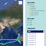
This map represents the journey of the whaler Neptune (Mystic Seaport Museum O-LOG 23) of New London, Connecticut. Chronicling the ship’s voyage from October, 1840 – April, 1842, the map depicts the ship’s day-to-day events as it traveled to the South Atlantic and Indian Oceans as they were described in the ship’s logbook. View the active map →

Original content by: Allyse Zajac

The collaboration

This voyage of Neptune is American Offshore Whaling Voyage AV10372. Our database includes summary information about the voyage, the vessel and the master, Samuel Greene, Jr., as well as a crew list.  In building her interactive voyage map, Allyse Zajac started with AOWL logbook data then added detail, encoded special events, and transcribed all of the complete logbook entries from the original logbook in the collections of Mystic Seaport Museum.

In the next phase of our project, we hope to take the data set from her project and  use it to enhance the information on whalinghistory.org.


Oil & Bone: American Ports in the Golden Age of Yankee Whaling

By Kerry Gathers

At its peak in the mid-19th century, whaling was a gigantic, global business that provided oil to light the streets and homes of Europe and America, and bone to make profitable consumer goods for sale around the world. The young United States dominated this industry, and for a time, whaling was the fifth largest sector of the American economy.

While stories of whaling drama, adventure, and violence are typically set at sea, this map aims to communicate the economic impact of whaling back in American ports, where sperm oil, whale oil, and whalebone landed and entered the market. For over 60 port cities and towns, this map reports the market values of whale products as they were returned to port from 1804 to 1876, illustrating the drastic ebbs and flows of the industry.

Oil and Bone Map
Click on image to enlarge. Interact with the map at www.kgmaps.com/oil-and-bone


British Whaling data now available

WhalingHistory.org is now hosting two important data sets documenting British whaling.

The databases contain voyage and crew information for the British Southern Whale Fishery, which operated from 1775 to 1859. The voyage database, which is primarily the work of A G E (Joe) Jones, documents the events of about 2550 voyages, whaling or sealing, to the south of Britain in over 930 different vessels. The crew database, which is primarily the work of Dale Chatwin, lists nearly 14,000 entries for men who sailed in the ships in the British Southern Whale Fishery.

For 350 years until the early 1960s the British were involved in several types of whaling. This involvement was divided into three distinct trades: the northern whale fishery between 1610 and 1914; the southern whale fishery or ‘south seas trade’ from 1775 to 1859; and the modern whaling trade, from 1904 to 1963. Each of these trades was distinguished by the geographical location in which it was undertaken, the types of whales pursued, and to some extent by the methods and techniques used to capture whales. The northern and southern whale fisheries were even differentiated and defined by law.

We are especially pleased to host the BSWF data because many American whalers also sailed from British ports in the years after the American Revolution. We are looking forward to making these connections explicit, linking records in the American Offshore Whaling databases with those in the British Southern Whale Fishery data.

World’s Most Comprehensive Whaling History Database Released

WhalingHistory.org connects all things whaling for researchers, scholars, genealogists and enthusiasts

The New Bedford Whaling Museum and Mystic Seaport Museum have developed the world’s most comprehensive whaling history database and it is now available for all to use at whalinghistory.org. Researchers, genealogists, students, teachers, and history buffs alike will find it to be the most robust and useful repository of whaling history documentation and scholarship.

The data presented combines many sources including logbooks, journals, ship registers, newspapers, business papers, and custom house records. Users will be able to find and trace whaling voyages and ships to specific logbooks, as well as the list of crew members aboard most of the voyages. The foundational fabric of Whaling History features three databases that have been stitched together – the American Offshore Whaling Voyage (AOWV) database, the American Offshore Whaling Log database, and an extensive whaling crew list database. All data is open to the public and is downloadable for any researcher to use with other tools and systems.

The American Offshore Whaling Voyage (AOWV) database, which was spearheaded by Judith Lund, scholar and former curator at the New Bedford Whaling Museum, includes information about all known American offshore (or “pelagic”) whaling voyages from the 1700s to the 1920s. It does not include the modern factory ship voyages of the mid-20th century. Information is most complete for the 19th century. The voyages included in the database sailed from, or were under the registry of, what is now the United States.

Extensive records of American whaling in the form of daily entries in whaling voyage logbooks and contain a great deal of information about where and when the whalemen found whales. The second part of the database’s foundation is the American Offshore Whaling Log database, which includes information from 1,381 logbooks from American offshore whaling voyages between 1784 and 1920. These data were extracted from the original whaling logbooks during three separate scientific research projects, one conducted by Lieutenant Commander Matthew Fontaine Maury in the 1850s, the second conducted by Charles Haskins Townsend in the 1930s, and the third conducted by a team from the Census of Marine Life project led by Tim Denis Smith between 2000 and 2010. The data file includes 466,134 data records assembled in a common format suitable for spatial and temporal analysis of American whaling throughout the 19th century.

The third database that Whaling History is built from is extensive whaling voyage crew lists from more than 5,300 voyages. Crew lists for whaling voyages recorded at the customs houses in Fall River and Salem, Massachusetts and in New London, Connecticut have been compiled as part of various projects and from various sources over the years. Crew lists for New Bedford voyages have been compiled using records kept by the chaplains of the New Bedford Port Society from 1840 to the end of whaling in New Bedford. These crew lists are now in a single searchable, sortable database.

In the next phase of the Whaling History, museums and other institutions’ collection items will be able to be linked to the database, giving researchers the ability to see a robust and dynamic picture of whaling history and artifacts.

Spatial and Seasonal Distribution of American Whaling and Whales in the Age of Sail

This map showing the spatial distribution of American Whaling and Whales in the 17th to 19th century was created using AOWL data. This and other maps are presented in:

Smith TD, Reeves RR, Josephson EA, Lund JN (2012) Spatial and Seasonal Distribution of American Whaling and Whales in the Age of Sail. PLoS ONE 7(4): e34905.
https://doi.org/10.1371/journal.pone.0034905

Abstract

American whalemen sailed out of ports on the east coast of the United States and in California from the 18th to early 20th centuries, searching for whales throughout the world’s oceans. From an initial focus on sperm whales (Physeter macrocephalus) and right whales (Eubalaena spp.), the array of targeted whales expanded to include bowhead whales (Balaena mysticetus), humpback whales (Megaptera novaeangliae), and gray whales (Eschrichtius robustus). Extensive records of American whaling in the form of daily entries in whaling voyage logbooks contain a great deal of information about where and when the whalemen found whales. We plotted daily locations where the several species of whales were observed, both those caught and those sighted but not caught, on world maps to illustrate the spatial and temporal distribution of both American whaling activity and the whales. The patterns shown on the maps provide the basis for various inferences concerning the historical distribution of the target whales prior to and during this episode of global whaling.

Townsend’s Whaling Charts

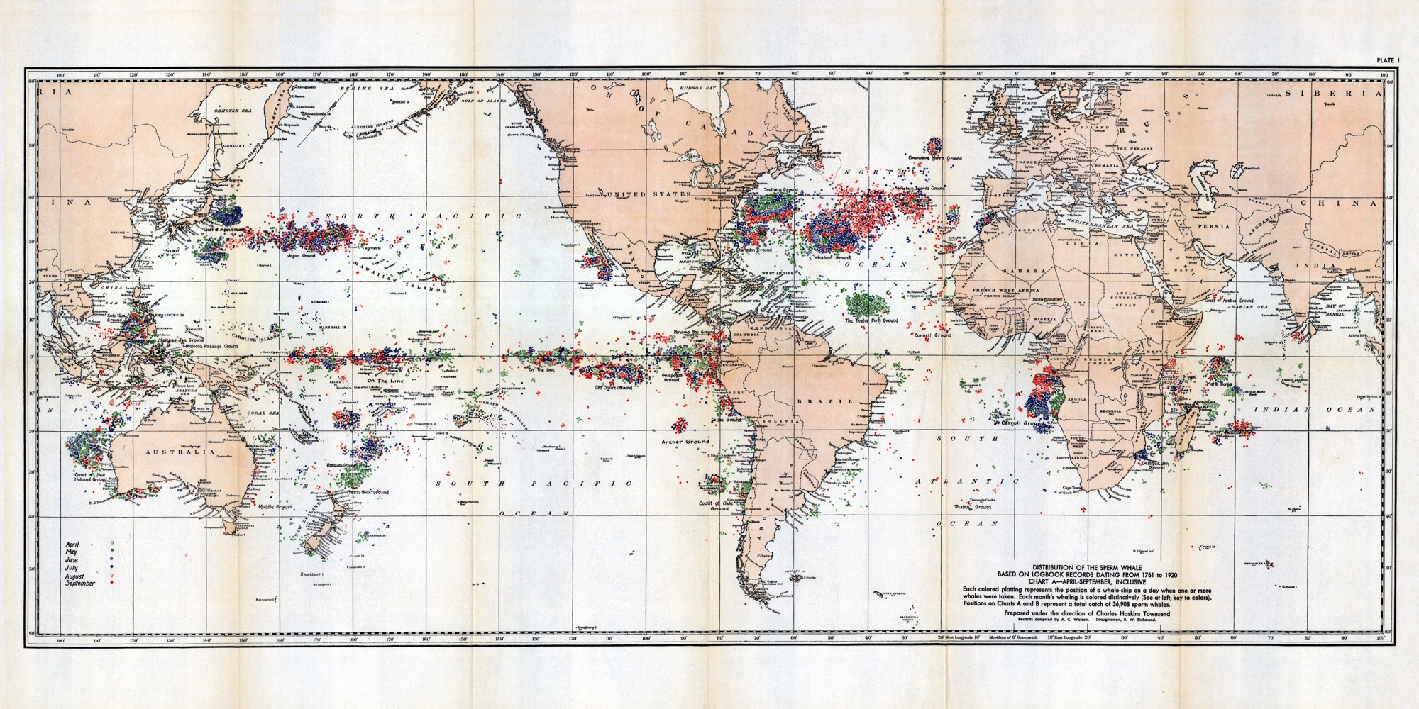
Chart A: Distribution of the sperm whale based on logbook records dating from 1761 to 1920. April – September, inclusive. (Click on any chart to enlarge.)
Chart B: Distribution of the sperm whale based on logbook records dating from 1761 – 1920 October—March, inclusive
Chart C: Distribution of northern and southern right whales based on logbook records dating from 1785 to 1913.
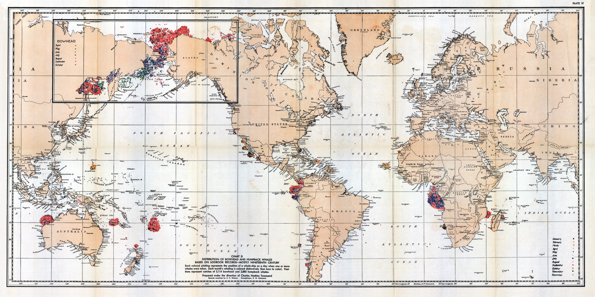
Chart D: Distribution of bowhead and humpback whales based on logbook records – mostly Nineteenth Century.

From Townsend CH (1935) The distribution of certain whales as shown by logbook records of American whaleships. 19. Zoologica (NY): : 1–50+6 Charts.

For a dataset that corresponds in part to these charts, visit Townsend’s Logbook Data →

For more information and chart scans, visit WCS Canada →

Honolulu, Nov 2nd 1859

To: Mystic Seaport, Collections Research Center
Date: 23 November 2017

Sir:

When my older brother died last month, his widow sent me a box of family papers, much of which I was totally ignorant of. Among them was a letter dated Nov 2nd 1859, from Honolulu, Sandwich Islands. The letter was from, I assume, a crew Member to his mother. In it he expresses regret at the news of his father’s death and guilt that he wasn’t there to help console the family. He writes that there are presently about 80 ships in port, mostly whalers, and he has met many men from Hartford. He also notes that they were “in the Ochotsk Sea six months and have on board one thousand barrels of oil and 8500 lbs of bone”. He signed the letter “From your ever affectionate and dutyful son, Sidney Case.” He then writes “Please direct Honolulu Sandwich Island in care of Cpt Davey (Davis?) “Barque Gratitude” The hand writing is very formal and ornate, the letter has been folded, unfolded numerous times and at some point the folds were taped making much of it difficult to read. I would like to confirm that “Sidney Case” was a crew member, and then try to determine what connection he had with my family (Gilmore (Gillmore) and Randall). Any information you can provide is appreciated.